Community
Zion National Park Continues to Amaze
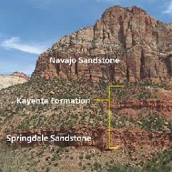
Zion National Park, located in southwestern Utah, is a showcase of geologic time and natural forces sculpted into one of the most striking landscapes on Earth. Its towering cliffs, deep canyons, and multicolored rock layers reveal a story spanning more than 150 million years, recording environments that once ranged from vast deserts to coastal plains and shallow seas.
At the heart of Zion’s landscape is the Navajo Sandstone, the massive cream-colored formation that forms the sheer cliffs of Zion Canyon. Deposited around 190 million years ago during the Jurassic Period, this sandstone originated as enormous desert sand dunes—some over 1,000 feet high. Over time, these dunes were buried, compacted, and cemented into stone. The cross-bedding patterns visible on many cliff faces still record the sloping angles of the ancient dunes, frozen in rock. The hardness and uniformity of the Navajo Sandstone make it both erosion-resistant and visually dramatic, giving rise to Zion’s iconic monoliths such as Angels Landing and the Great White Throne.
Beneath the Navajo Sandstone lies a sequence of older formations that tell of changing environments. The Kayenta Formation, composed of reddish mudstones and sandstones, represents ancient rivers and floodplains that once meandered across the landscape. Below that, the Moenave and Chinle Formations (to the left) preserve evidence of lakes, streams, and lush lowlands that existed in the Late Triassic, including fossilized dinosaur tracks and petrified wood. Each layer marks a different chapter in Zion’s prehistory, showing how climates shifted over time from wet and tropical to dry and arid.
Zion’s modern landscape began to take shape much later, when powerful tectonic uplift raised the entire region during the late Cenozoic Era, about 5 to 10 million years ago. The Colorado Plateau, of which Zion is a part, rose thousands of feet, dramatically increasing the gradient of regional rivers. The Virgin River, flowing through the center of the park, responded by cutting downward into the uplifted rock. Over millions of years, it carved the deep, narrow Zion Canyon we see today—up to 2,000 feet deep in some places. Though the Virgin River may seem small, it is relentless, its seasonal floods moving immense quantities of sediment and continuing to sculpt the canyon floor.
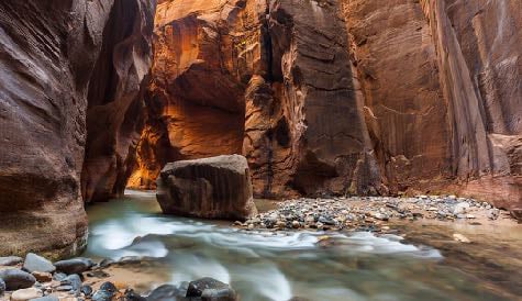
Erosion remains the dominant force shaping Zion. Water, freeze-thaw cycles, and gravity combine to create new features continually—slot canyons like The Narrows, natural arches, and the talus slopes beneath cliffs. Flash floods, while dangerous, are an essential part of this geologic process, rapidly scouring and reshaping narrow gorges.
The park’s color palette—ranging from deep reds and oranges to creamy whites and purples—comes from varying mineral content in the rock. Iron oxides produce reds and yellows, while manganese gives purplish hues. These colors, especially at sunrise or sunset, emphasize the layering and complexity of Zion’s geologic story.
In essence, Zion National Park is a masterpiece carved from the Earth’s memory. Its cliffs are pages of deep time, recording the slow accumulation of sand, the rise and fall of ancient landscapes, and the ceaseless power of water and uplift. Visitors walking through Zion Canyon are literally traveling through millions of years of geologic history—an ever-evolving testament to the planet’s creative and destructive forces.
The sands that eventually formed Zion National Park’s Navajo Sandstone—the park’s most prominent and visually stunning rock layer—blew in from … well, there are two chains of thought, the Pacific Northwest origin of the massive amounts of Navajo sand and the Easterly origin of the sediments. Both ideas have proponents and I’m not sure we will ever know for certain.
Nevertheless Mother Nature is a marvelous re-cycler. The sand grains originated somewhere, east or west, settled into place during the Jurassic Period, were buried beneath thousands of feet of other sediments, then exposed by virtue of the Colorado Plateau uplift and the Mighty Virgin River. The surrounding cliffs are the result of that cycle of deposition and erosion. And the cycle continues with the Virgin carrying the same grains of sand down river to Lake Meade, into the Colorado River and then being deposited in river deltas in the Sea of Cortez (Gulf of California) much like the deltas of the Mississippi River in the Gulf of America, and can easily be seen on Google Maps. The grand cycle continues.